Stuff like this fascinates me. The video is made from actual footage from cameras that rode along on two different shuttle flights, and shows the view from one of the booster rockets. The sounds I think are artificial (added after the fact by Skywalker Sound) but still add a lot to the effect of the video.
Hat tip to Break.com (for this one, and lots of other entertaining posts!)
That’s pronounced “my-ya” (except the second syllable in Dutch sounds different.) The Meije is the quaint little road that leads to my sister- and brother-in-law’s dairy farm near Bodegraven in The Netherlands. I became very familiar with the road during our visit there in May this year; very beautiful place.
Sorry for the soundless video; I did add a few comments along the way as I drove, but the camera’s mic didn’t pick it up very well. One of these days I’ll take the time to figure out how to add commentary and a soundtrack, but until then the visual aspect is all we get. Use your imagination!
Meije is also the name of a collection of homes, a church, a school, and a coffee shop that could maybe be called “a village” but I’d stop short of that (if you watch through to the end of the video, Meije is where I stopped recording & turned the car around.) But the road is what most people in the area think of when they hear the word. Le Meije also happens to be a peak in the French Alps, but I doubt the folks that live along the Meije in Holland hear much about that one, nor care much about it.
As roads go, the Meije is about as narrow as they get, with barely enough room for one-way traffic, but it still accommodates two-way traffic. Making matters worse more interesting is the fact that many of the houses have hedges & fences right up to the road, and in other places there is a drop-off one one side or the other with water at the bottom; no good-old-fashioned WPA ditches like you find in South Dakota! When another vehicle approaches from the opposite direction, both drivers have to move as far to the right as possible. Often though you’ll find yourself head-to-head with a truck or tractor, and there just isn’t room for both of you; in those cases it’s customary for the smaller of the two vehicles to back up and into a driveway to allow the other to pass by. I had it happen once, but thankfully, most cars are small and there are lots of driveways and several bump-outs along the way to make it a little easier.
This photo features het Potlood, (the Pencil) which is a water tower that services the village and the homes along the Meije. It’s a well-known landmark that can be seen from many miles distant; very unique bit of architecture!
The area is historically a farming community. Most all of the houses along the road were at one time farm houses, but the area is becoming slightly more urban, or bedroom community-ish; with the popularity of the road, many of the houses are no longer occupied by farmers. Even though the working farms are fewer these days, their presence is unmistakable, evidenced by the “dairy farm” odor… There’s no escaping the smell of cows and their, um, byproducts. It’s no wonder when you consider how many head of cattle inhabit the area and how the the farmers deal with the waste from all of them.
From what I gathered, most of the houses along the Meije were built in the early 1900’s, and display similar construction methods; brick exterior, timber roofs with either tile or reed (thatch) roofing. Many of the buildings, while quaint & charming and all that, aren’t much to write home about on the inside. The soil in the area is very soft, and as a result the foundations of many homes aren’t very stable. Dick & Michelle’s house has wall that has settled considerably, and I saw several other buildings along the road that appeared to have off-kilter walls or the whole house was slightly askew. That doesn’t seem to bother the owners though; they keep their places up as would any fastidious Dutchman. Some are definitely nicer than others, and some residents put a great deal of effort into the gardens along the road, which only adds to the enjoyment of the drive. There are few basements, for obvious reasons.
The GPS unit that we borrowed showed that the area was about three meters below sea level. About 27 percent of the Netherlands is below sea level; it’s land that has been reclaimed by the building of dikes to push & hold back the sea. The area around the Meije is part of that reclaimed land, and is about as flat as a pool table. The different properties that line the road are separated by canals rather than fences. Most of the canals I saw were about three meters wide and probably about that deep in the center.
It had been fairly dry in the months preceding our visit, so the water level was down a bit, but there was always plenty of water in the canals and plenty of waterfowl around; ducks, geese, swans and storks. One interesting thing with the canals along the road; on the north side of the road (left in the video) is a larger canal that connects to a small lake, and the water level is several feet higher than the canals on the south side of the road. I suppose the road acted as a levee separating the two. In many places the canal runs right next to the road, which required bridges to be built on many driveways to allow access. Some of the homes even sported drawbridges at the road! How cool is that?
When viewing the area from above, as on Google Maps or Google Earth, you can see that the canals run parallel to one another to form fields in the shape of long rectangles. It was surprising to me to see how many farms & homes were packed along the road; in rural parts of the US there can be pretty large distances between farm places.
The Meije is far from the coast and any sizable dikes, but one day Yvonne & I did trek northward to visit the towns where her mom & dad lived when they were younger. Her mom lived in the town of Andijk, which is pronounced “on-dike” and is very literally built right on — or inside — the dike. I was pretty amazed at the dike; it’s an earthen structure that rises a good 30 feet or more from the road’s surface at its foot, but on the other side the water is only about 10 feet below the crown of the dike.
This is two photos stitched together (rather poorly; the light was very different in the two exposures and I couldn’t get the clouds quite right!) to show the difference between the two sides. The town would be completely submerged if not for the dike. A tremendous degree of confidence in the integrity of the dike is on display in Andijk; there are two 100-plus year old churches within a stone’s throw of the dike as well as several hundred homes.
This is getting a bit long… I started writing the post a month or so after returning, but kept adding a little bit here & there, even though I didn’t intend for it to turn into a travelogue. It really was a great trip, especially our time spent touring Germany. And our day trip to the Swiss Alps… Pretty sure Heaven will look very much like what we saw there! Didn’t enjoy the language problem though; will not be returning to Europe until I know a enough German and Dutch to get by. Will have to post some more photos sometime.
Caleb & I drove up to the Twin Cities to go to the Mall of America & goof around a bit. Actually, the Mall thing was more of a secondary excuse for going there, as I’d arranged to buy some needed BMW parts from a guy in St. Paul who was parting out a 528e. But we had a great time at the theme park inside the mall, so it was a great excuse to get us up there!
Anyway, when we finally got to the mall, found a parking spot and walked into the building, we bumped into my niece Kelsey and her mom, my brother’s ex-wife. Wow; what ARE the chances of that happening? For us to be walking in the fourth floor east parking ramp entrance at the same moment that they were walking out the same entrance… It kinda boggles the mind.
We didn’t exactly get to the mall directly… We drove up 35W, and I was looking for signs along the freeway that would tell me which exit to turn off to get to the mall, and didn’t see anything. When I finally decided we’d gone too far north, we were at the University of Minnesota (go Gophers!) Checking the map, I saw that where we were was directly north of the mall (way north, by about 15 miles!), so rather than taking 35W back south, we took the more circuitous route through the city, following Cedar Avenue, which connects directly with Minnesota 77, which passed right by the mall.
That took us to a side of the mall that I hadn’t been to on my previous few visits, and that put us in the east parking ramp, which I guess is a mirror image of the west ramp, which I was originally aiming for. We made a couple of sorties into parking areas only to be frustrated by finding no empty spots. Caleb suggested that we go to the top floor, and I suggested the one just below so we’d be in the shade, so we ended up near the fourth floor. Then we couldn’t find a couple of things in the van and had to hunt around a bit for them. Then we headed into the building for the surprise…
It makes me wonder how things like that come about, and why. All those delays put us in the right place at the right time for something wonderful to happen. I’m a firm believer that there is no such thing as a ‘coincidence’. Things happen because they are allowed to happen and we’re guided to appointments that God has arranged for us. We don’t always know what the purpose of those appointments is, nor should we be consumed by trying to interpret what they’re all about… I just have to sit, slack-jawed in awe of the Master of the Universe who can coordinate things so… beautifully.
That incident reminds me of something minor that happened years ago; I happened to look out the back window of our house on Norton at the very moment that a leaf fell from our neighbor’s Silver Maple tree. It was a solitary leaf falling after most of the others fell, and that leaf fell in such a manner, and the wind guided it just so that the hook of the stem caught on a branch of a smaller tree at the back of our yard. Like yesterday’s ‘coincidence’, that made me sit back in wonder at how intricately woven our lives are, and how awesome is the God who orchestrates this marvelous tapestry of our lives.
On our Kentucky visit last week, we intentionally drove some of the two-lane highways when traveling between the sites we visited, and the rural Kentucky scenery made the longer drive times very worthwhile. After our Mammoth Cave tour we had dinner in Cave City, KY, then drove Highway 31W back to Elizabethtown. Not too far down the road we happened across a very special sight, the Wigwam Village Inn.
The sign welcomes visitors to stop and “Sleep in a Wigwam”, and offers fifteen teepee-shaped rooms, complete with modern amenities, arranged in a semicircle around the main teepee in the center. The name of the place confused me a little, as the term ‘wigwam‘ is usually associated with a dome-shaped hut used by Native Americans, while the structures in the Wigwam Village were more like tipis… I won’t argue semantics with them though; wigwam or tipi, they are definitely cool!
The history of the Wigwam Village Inn is interesting; turns out that the one we saw is one of seven that were built some 70 years ago, and they even have a tie to South Dakota!
Wigwam Village Inn No. 2 began as a dream of Frank A. Redford in the early 1900s. Frank’s inspirations in this dream were a popular ice cream shop shaped like an upside down cone and authentic teepees he’d seen on a Sioux reservation in South Dakota. His dream became reality in 1935 when construction on Wigwam Village #1 was completed in Horse Cave, Kentucky. Realizing he’d hit upon a popular idea, Frank patented the design with the US patent office in 1936.
Wigwam Village Inn #2 was completed in 1937 in Cave City, and five more were built over time in Alabama, Florida, New Orleans, California, and Arizona… Of the seven original Wigwam Villages, only three remain: #2 in Cave City, Kentucky, #6 in Holbrook, Arizona. and #7 in Riallto, California. Wigwam Village #2 is an impressive sight and is truly a monument to one man’s American dream that came true.
When we saw it, my first thought was, “This is where they came up with the idea for the Cozy Cone Motel in Pixar’s Cars!” Sure enough, the website for the California Wigwam Village confirms that thought. And it fits right in with the Route 66 theme in Cars, because that Village is located right on the real Route 66.
When we drove by the Village in Cave City, I knew it was pretty cool, and I’m glad I at least stopped to take pictures. But had I known that the place was this old and unique, I definitely would’ve at least stopped in the gift shop. Next time I’m in Kentucky…
I can remember drooling over the Moller SkyCar since the first time I saw renderings of it on the pages of Popular Science or Popular Mechanics decades ago. The thought of being able to hop into a machine that would lift off from your own driveway and zip you to your destination at speeds around 300 mph, far above traffic… What a wonderful thing that would be! A vehicle that is able to perform like a high-performance airplane, but as easy to drive as a car.
Yesterday evening I at long last took possession of a Moller M400 SkyCar. It’s true! You would think my joy would be complete, but given the fact that what I’ve got is only a toy…
Yes, it’s just a HotWings diecast model of the SkyCar. Not very fulfilling, but still not a bad deal for $1.98 at Target!
The dream that is the Moller SkyCar remains just that; a dream. Since the idea was first introduced, the SkyCar’s inventor, Paul Moller, has failed to deliver a single working prototype of the SkyCar. That combined with Moller’s readiness to accept deposits from hopeful SkyCar buyers has led to accusations that the whole thing is a scam. Moller seems to put out a press release and make a big splash every now & then, which some say coincided with a need to generate some cash or deflect heat he’s getting from investors or government regulators. Part of me believes that to be true, but the more likely case is that Paul Moller is simply trying very hard to make his dream come true — he just doesn’t have the where-with-all to make it happen. The really unfortunate part is that he’s spent somewhere in the neighborhood of $200 million in the process, much of that coming from those hopeful investors, who won’t likely live to see any fruit from their investment.
The company is publicly traded, and while looking at their trading info I was surprised to see a recent Yahoo Finance story on Moller dated just a few days back; apparently the company is “in the process of completing its fourth M200 “Jetson” volantor airframe. It expects to complete forty of these fly-by-wire, multi-engine flying vehicles in 2009.” The M200 is vastly different from the M400 SkyCar; it more closely resembles a flying saucer, using multiple ducted fans around the single seat to provide lift and directional thrust vectoring. The M200G is limited to ground-effect flight at a mere 10 feet above the ground. (after a little more digging, the Yahoo story seems to be a rehash of a press release that got much broader coverage back in July. Nothing new.)
The design of the SkyCar seems to have morphed a bit over the years; the rotating ducted fan nacelles on stubby wings you see on the early renderings and on the diecast toy seem have been replaced by what looks to be fixed nacelles with thrust vectoring vanes, no forward wing, and a much larger rear wing. Some images I’ve seen show the rear wing folding up and over the rear engines, probably so it can fit in a garage (suppressed chortle).
The SkyCar always has been a really, really cool idea, but I’m afraid the technology to make it work just hasn’t arrived yet. Engines powerful enough to get a vehicle, passengers & payload off the ground are too heavy to make something like the SkyCar practical, and fuel will I won’t get to fully realize my dream, but maybe my kids, or their kids, will.
Today, June 6, is the 63rd anniversary of D-Day; the Battle of Normandy Beach. I’m not a military history buff by any stretch of the imagination, but I do know what June 6 means, and can’t think of the sacrifice made by so many men without getting choked up. Almost 1.5 million Allied forces involved in the invasion, against 380,000 Nazi soldiers at Normandy. Over 57,000 Allied soldiers killed, another 180,000 injured or missing. All in one single military operation. Makes the four years in Iraq look like a drop in the bucket.
I won’t try to summarize what happened that day, but if you’re interested in learning something about it, here are a couple of good sources: Go to Normandy1944.info and click on Veteran Stories; some fascinating tales there. Also, PBS has a nice American Experience section on D-Day. There’s a tourist-oriented site operated by the French; NormandieMemoire.com, and don’t forget the ever informative Wikipedia.
Here is something interesting; the audio of the prayer broadcast by Franklin D. Roosevelt on that fateful day. Incredible words (a transcript of FDR’s speech can be found here.)
Here’s a slightly funny photo; newborn calves hanging on a fence! Get it? Cows-Line — Clothes-Line! (ok, bad joke.) And in case you’re wondering, the calves are not dead; they are just fine.
We spent Mother’s Day in the thriving metropolis that is Maurice, IA. And a day in Maurice (pronounced “mawr-is”, as in “morris”) isn’t worth much if you don’t visit the park and take a ride down The Famous Maurice Fire Escape Slide.
The Famous Fire Escape Slide can’t be terribly famous; a Google search comes up pretty much empty. I found one post in a Blogspot archive by a guy named Steve-O, writing about stuff to do around Sioux Center, IA (must be a Dordt alumnus.) Steve-O’s post somewhat confirms what little I know about the slide; that it used to be the fire escape for the second floor of the school. I don’t recall ever seeing a school building in Maurice, so it must’ve been bulldozed after the Maurice & Orange City school districts merged.
Anyway, the slide looks like a steel-clad silo, but you climb the stairs to the top, jump into the hole, and it dumps your butt on the ground below after twisting you around a couple of times on the way down.
The rest of park there is just as great; not only does it feature The Famous Maurice Fire Escape Slide, but also a swingset that has the crossbar about 15 feet off the ground, and real honest-to-goodness teetertotters! And not the emasculated ones, but the ones that will truly emasculate you if improperly used. Built from 2×12 lumber, angle iron for bracing across the middle, welded steel tube handles at each end, and a four-foot high center, these puppies could cause serious injury. Removes any doubt why they are so hard to find in our litigious modern age. The only question left is why they remain in Maurice!
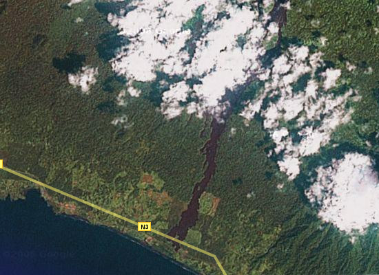
Here is a Google Maps satellite image of the lava flow in Cameroon we saw when there in January, 2004.
Mount Cameroon erupted last in 1999, and left this huge lava flow. While the flow is a mightily impressive sight, the really strange thing is that the lava flow stopped just a few meters after crossing a highway. The lava mound is huge — about 15 meters high and at least 30-40 meters wide — and for years was too hot for local officials to do anything about. So there it sits, blocking the highway. No fear though; the enterprising Cameroonians just carved a bypass through the jungle & made a path around the lava.
The image resolution isn’t great — it’s much better a little further to the south, but not for this spot yet — but this gives you a good idea of its size. It’s a little over 1 kilometer from the flow to the edge of the image above. You can click on the image to go to Google Maps, where you can zoom in a little more and move about. If you turn off the labels, you can see the lava flow and the line in the foliage formed by the road, intersecting the flow at the very end.
Too bad the resolution isn’t any better, or it might give a good look at the beautiful black sand beaches at the foot of the volcano. Being from the US, I’d never seen sand colored anything but shades of white to “sand” colored.
Here is a link to a website with more specific information on the Mount Cameroon eruption.