Here is a Google Maps satellite image of the lava flow in Cameroon we saw when there in January, 2004.
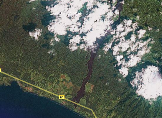
Mount Cameroon erupted last in 1999, and left this huge lava flow. While the flow is a mightily impressive sight, the really strange thing is that the lava flow stopped just a few meters after crossing a highway. The lava mound is huge — about 15 meters high and at least 30-40 meters wide — and for years was too hot for local officials to do anything about. So there it sits, blocking the highway. No fear though; the enterprising Cameroonians just carved a bypass through the jungle & made a path around the lava.
The image resolution isn’t great — it’s much better a little further to the south, but not for this spot yet — but this gives you a good idea of its size. It’s a little over 1 kilometer from the flow to the edge of the image above. You can click on the image to go to Google Maps, where you can zoom in a little more and move about. If you turn off the labels, you can see the lava flow and the line in the foliage formed by the road, intersecting the flow at the very end.
Too bad the resolution isn’t any better, or it might give a good look at the beautiful black sand beaches at the foot of the volcano. Being from the US, I’d never seen sand colored anything but shades of white to “sand” colored.
Here is a link to a website with more specific information on the Mount Cameroon eruption.
Alright, 72474460billy at msn dot com; I don’t know exactly what to think about the comment you’ve left here twice (and I’ve marked as spam twice). But if you want me to leave it up for some reason, please write something more than an undecipherable string of code and “None…”
Until then, in my eyes you’re a spammer and your comments will be treated as such. If you’re a spy or a terrorist trying to use my obscure little blog to pass messages to your cohorts, find another venue dude. Sorry.