Last night we experienced a rather weird and rare weather phenomenon. It’s called a Convective Heat Burst.
About 4 a.m. this morning I woke to the sound of shrieking winds and tree branches falling on the roof. I looked outside & saw that a good-sized branch had fallen from the maple tree, so I went outside to check & see if there was any damage. One step outside the back door and I knew something was up; it was like walking into a sauna — hot!
The wind was still howling and it was beginning to rain, but thankfully, there wasn’t any damage to the house & the large branch had fallen between our house and the neighbor’s garage on the fence & but small branches were scattered everywhere. The wind died down shortly afterward, and I could feel the temperature dropping while I was out there. It was strange; really strange.
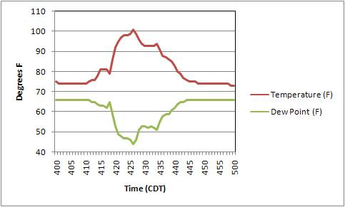
This afternoon I went digging around on the Internet to see what I could find out about what went on this morning; KELO-TV had a blurb on their website and their blog about it which provided me with its name, and of course Wikipedia has a page on it, which was even updated with this morning’s event; how about that! I posted a question to the KELO blog about it and Tony Barlow responded with a little more information on it and a link to another website describing the phenomena. The graph below (click on the image for a slightly larger version) also came from Tony and the KELO blog.

Turns out that meteorologists don’t know for sure what causes a heat burst but they always happen when a thunderstorm cell is dying. It’s theorized that it starts when rain hits a pocket of dry air at about 10-20,000 feet and quickly evaporates. The evaporating moisture causes the air to become more dense than the surrounding air, which causes it to descend rapidly. During the rapid descent the air mass is compressed, which causes its temperature to rise sharply. When that mass of air hits the ground, you get high winds and hot, dry air. The link provided by Tony mentions that the hot dry air is capable of killing vegetation by quickly pulling the moisture out of it, and in some cases the heat can stick around for quite some time.
According to the chart above the temperature was about 73° prior to the event. Within a very short time period the temp jumped to the 101° high, then drifted back down to about 72°. According to the Wikipedia entry, a heat burst occurred in Brazil in 1949 causing the temp to jump from 100°F to 158°F in two minutes!
I had never even heard of a heat burst before, much less experienced one, so in a way I’m glad for the large downed branch laying in my yard, in spite of the extra work it means… If it weren’t for that I wouldn’t have been outside at 4a.m. to experience the heat; and if it weren’t for that I wouldn’t have been curious enough to go looking for the reason behind that and the wind accompanying it.
Update:
The National Weather Service posted a report on the heat burst event; not sure whether they’ll keep it online or not, so here’s the text and images from that site, just in case.
Convective Heat Burst moves across Sioux Falls
Between 415 am and 445 am CDT this Sunday morning August 3rd, the city of Sioux Falls experienced a convective heat burst. Temperatures rose rapidly from the lower 70s to 101 degrees in a very short time. This rapid rise in temperature was also associated with wind gusts of 50 to 60 mph, as well as a rapid drop in dew points. The official high temperature will be 99 degrees as with automated weather stations, only the 5 minute mean temperature and dew point are used.
A heat burst occurs when warm air from 10,000 to 20,000 feet above the surface is forced to the ground. Typically when air comes down to the surface with thunderstorms, it is much colder than the air at the surface. However, especially during the late night and morning, very warm air can be forced to the surface if the air reaches the surface without rainfall occurring. When this happens, the temperature will rise as much as 30 degrees, and the dew point will drop by 20 to 30 degrees. Heat bursts are also accompanied by strong to damaging winds. However, unlike many cases with damaging thunderstorm winds, little to no rain will fall when the heat burst occurs. This is because if it were to rain, the air would rapidly cool and moisten due to evaporation.
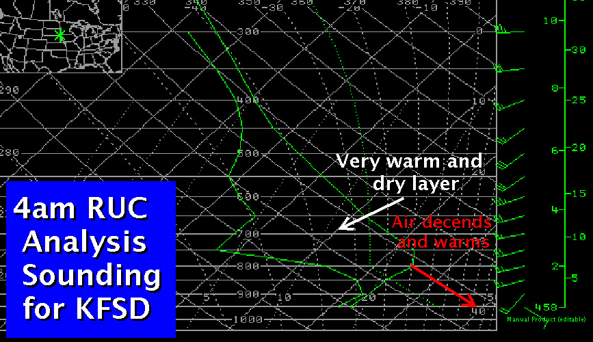
Here is an analysis sounding for Sioux Falls from the 09z Rapid Update Cycle model. Note the presence of the warm and dry layer aloft.
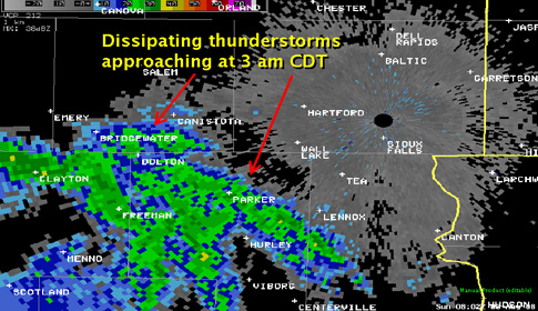
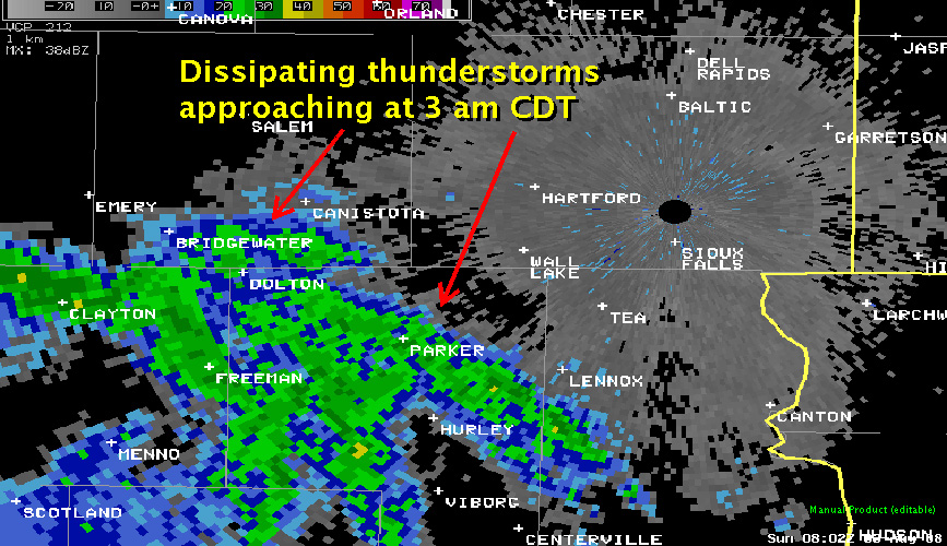
At this time, a dissipating thunderstorm complex which originated late evening across northern Nebraska was approaching from the southwest. The image below is the Sioux Falls base reflectivity scan, intercepting the returns at around 16,000 ft above ground level (AGL). While not shown, the returns weakened considerably below this level, and continued to weaken after this 3 a.m. CDT image.
As this rain evaporated into the warm and dry layer shown in the sounding above, the air cooled a bit and continued to subside. However, the evaporation cooling was not significant enough to offset the warming which occurs when an air parcel sinks, therefore, the parcel warms and dries on its continued descent to the surface. The red arrow on the analysis sounding above represents the necessary parcel trajectory to reach a temperature of 101 F, which occurred at 426 am CDT.
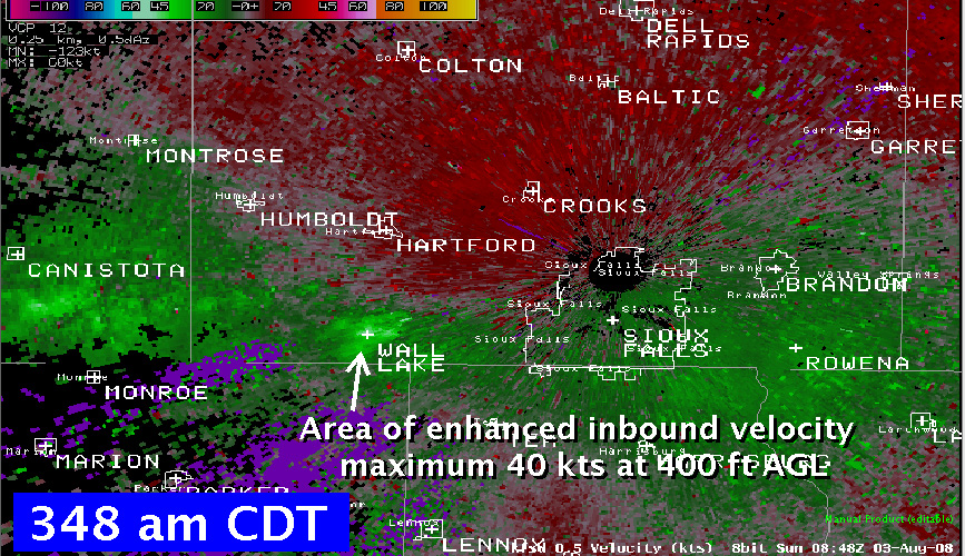
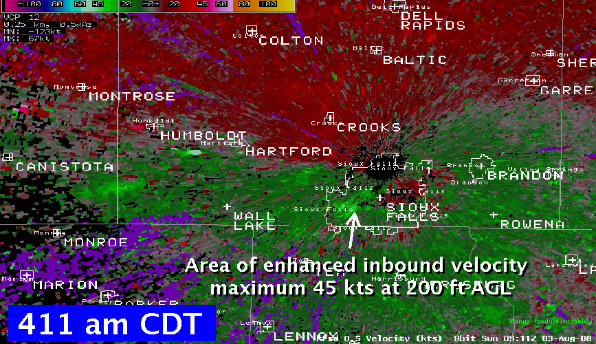
The first report of this phenomenon was received at around 3:45 am, when campers at Wall Lake called to report strong winds, and unusually warm temperature. Here is a radar velocity image from around this time. Note the area of bright green around Wall Lake, which represents the strong inbound winds reaching the surface, or here indicated at an altitude of 400 feet AGL.

The area of enhanced velocity was noted to be moving toward Sioux Falls after this time. The first report of the heat burst around Sioux Falls was some tree damage in central Sioux Falls at around 415 am CDT.
The heat burst was sampled by the automated surface observation system (ASOS) at Joe Foss Field. Below is a trace of the one-minute temperature and dewpoint data. The change from the background values of temperatures at 74 F and dew point of 66 F still present at 410 am CDT was quite sudden, reaching the peak change to 101 F / 44 F at 426 am CDT.
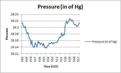
The measured station pressure also changed rapidly with time. The plot below shows the precipitous drop in pressure as the heat burst moved through, followed by a rapid rise once the system had passed.
Tags: convection, heat burst, thunderstorm, weather
OMG! This is sooo cool! I mean, HOT lol. You seriously don’t know how lucky you are! What’s weird is that I just found out about HBs last June…right after I found out about microbursts lol. I found out about the microburst the hard way…by having one hit my house. It’s basically the same thing, just not hot. Those are much more common. But I had been thinking about HBs all summer, hoping to see one (heh like that was gonna happen!) and just as I really got into them I found out about the one you saw! When I researched it, I found that another one had hit Sioux Falls in…I think it was 1998 or something. I think they are extremely fascinating. I know that they say they happen in the early AM because of the dying thunderstorms. But thunderstorms can be dying at any time of the day. Most happen in evening, so they would be dying around 8 or 9 instead of 4am. It must be something with the absence of sunlight. Since I am creative, I’ll have to research this heat burst thing LOL maybe find out something that isn’t known yet 😉 Thanks for posting this!! I’ve been looking for personal stories on this particular one.